


So far, Peter, yg, Chun See and Keith have got the answer correct in one way or another, but nobody scored full marks. Victor did not officially take part; he must have been too busy shooting himself in the mirror.
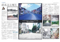
Peter made the first breakthrough by recognizing the foreground as SAF area. The place is labelled Kranji Camp (at Lorong Bistari) on my street directory. His closest guess was the ‘provost in Kranji’. He could have meant Mowbray Camp or Kranji Camp at Lorong Kebasi.
yj adopted a different strategy. He tackled the mountain instead. He hit the target by correctly identifying Gunung Pulai. But he didn’t answer the question which was about identifying my location. His latest guess was ‘Choa Chu Kang’ but I was looking for ‘Yew Tee’. Yew Tee today is at Choa Chu Kang North, separated by KJE from Choa Chu Kang housing estate.
Chun See was the first to blurt out Choa Chu Kang. He did it without identifying the SAF area (Kranji Camp) or the mountain (Gunung Pulai). The quiz would have ended if I left it at that. But I was waiting for the magic keyword. Not open sesame but Yew Tee.
Keith used yet another approach. He deduced the location from the golf course. I cannot spot the golf course in the photo but from my position, I don’t think Warren Country Club can be seen. His other guess, Kranji Country Club (more accurately Kranji Sanctuary Golf Club) may be right.
View Larger Map
From Yew Tee to Gunung Pulai: Straight line denotes light of sight to the mountain.
The following photos were taken from Yew Tee block 679 and 680.
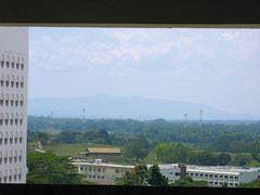
Original quiz photo taken from block 679. Foreground shows Kranji Camp.
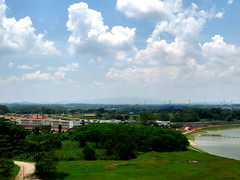
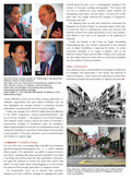
View from block 680. Sungei Kadut Canal on right. Do not be fooled by its smaller appearance here. The mountain looks larger in real life when viewed from the block.

School of Logistics/Combat Service Support at Kranji Camp. You can see both names in the picture.
(I have actually blogged about Gunung Pulai in my previous article.)


13 comments:
Yew Tee is the Mandarin name for what?????
Can u get a good view of the School of Signals or the KJE and Woodlands Road from this area? Would like to see
Nope, that block only has a good view of the north-west.
Yew Tee? Eh, the MRT Station is called 油池 - 'oil pool'.
I remember reading about the exact origins of Yew Tee's name somewhere, but it's slipped my mind... were there actual oily ponds there or was it just a figure of speech, I can't remember.
I wonder how many people actually live in Yew Tee. The few times I've passed by it I keep getting the impression that it's as dead as its namesake. I'm really curious about the life that was there before the HDBs and MRTs - I only have this 1991 street directory but you can see the full extent of Stagmont Ring (which looks more like half a ring and is now truncated to a really tiny bit of road as it's replaced by CCK North 5/6) and the very long roads of Lorong Kebasi and Lorong Bistari (now leading to army camps I think). I can't stop wondering what life was like back when this map was drawn, and it wasn't even so long ago. Did people really have to walk so far to get to Woodlands Road, and so on.. and why is Stagmont Ring the only English name among so many Malay ones - remnants of old British camps, perhaps? There's a Stagmont Road in the south...
Another place of interest not far from where Icemoon took the picture would be the Jalan Gali Batu granite quarry, I believe. I kind of want to go in and see-see but I have this sinking suspicion entry is restricted. I only looked in from the main road when I went to visit the Guang Xiao Shan cemetery before the mass exhumations and I remember the caretaker told me that the forests south of the cemetery are used by the SAF (or was it that they're just left as Protected Area to stop people from doing illegal gambling there, I can't remember)
Actually I don't even know where is Yew Tee although I know there is an MRT stn by that name. I just guess by looking at the map.
There used to be WW2 oil storage tanks in that area which were destroyed by the advancing Japanese during WW2. Mayb that is how it got its name.
There was a SAF armored unit (41 SAB???) there at the end of Stagmont Ring - taken over from the British in 1971.
Could Yee Tee be the Mandarin name for Kranji?
Icemoon, if look north-west, can see kranji River or the Straits of Johore? Got photos to share?
On my way to JB besides seeing the big lobang on the ground which were once occupied by the oil storage tanks, there was a very big field which has many communication aerial masts like the one at the corner of Upper Jurong Road/Jalan Bahar.
icemoon, you misled us. i don't know what's the penalty for this. cannot bar you from future quizzes, right?
yew tee is part of choa chu kang. it is bounded by cck north 7, cck way, cck north 6 and cck drive.
so, chun see was right when he gave the answer as cck.
i am familiar with gunong pulai as i once drove up the narrow road, almost right up to where the transmitting station is. i stopped short of it because i was afraid of having problems with the security people.
i nver knew there were so many different SAF units in Yew Tee. What baout Paya Lebar Camp - heard was SAF. what they do that?
Peter, Kranji is the name of a tree. Yew Tee is Teochew for 'oil pond', named so after the oil stored there during the Japanese Occupation.
But Yew Tee Village was between Mandai Quarry and Woodlands Road. Today, Woodlands Road intersects KJE at .. surprise .. Yew Tee Flyover!. Therefore I believe Yew Tee MRT Station may not lie in the historical Yew Tee area. Should be called Choa Chu Kang North. Just like Bedok North and Bedok.
Anyway, I think oldies should be subjected to a higher standard. Haha.
KJE was actually the old Stagmont Ring - widened and extended to Woodlands Road
passerby, yes, the area between the teochew cemetery and the gali batu granite quarry is a protected area. there is actually a track that links these two places. in fact, there is a nicely paved road in between the area where they are constructing the largest mrt depot. this road has no lighting and there is a barrier that is down and locked at all times. the indonesian cigarette peddlers used to hide here but now they are hiding somewhere else, nearby.
yesterday, i just walked in that area. i came to a place with a high fence and barbed wire, with a sign that says: no taking of pictures. i guess this must be a military area.
Post a Comment